地球上的气旋路径
(原标题: Cyclone Paths on Planet Earth)
2021-09-15
浏览次数: 589
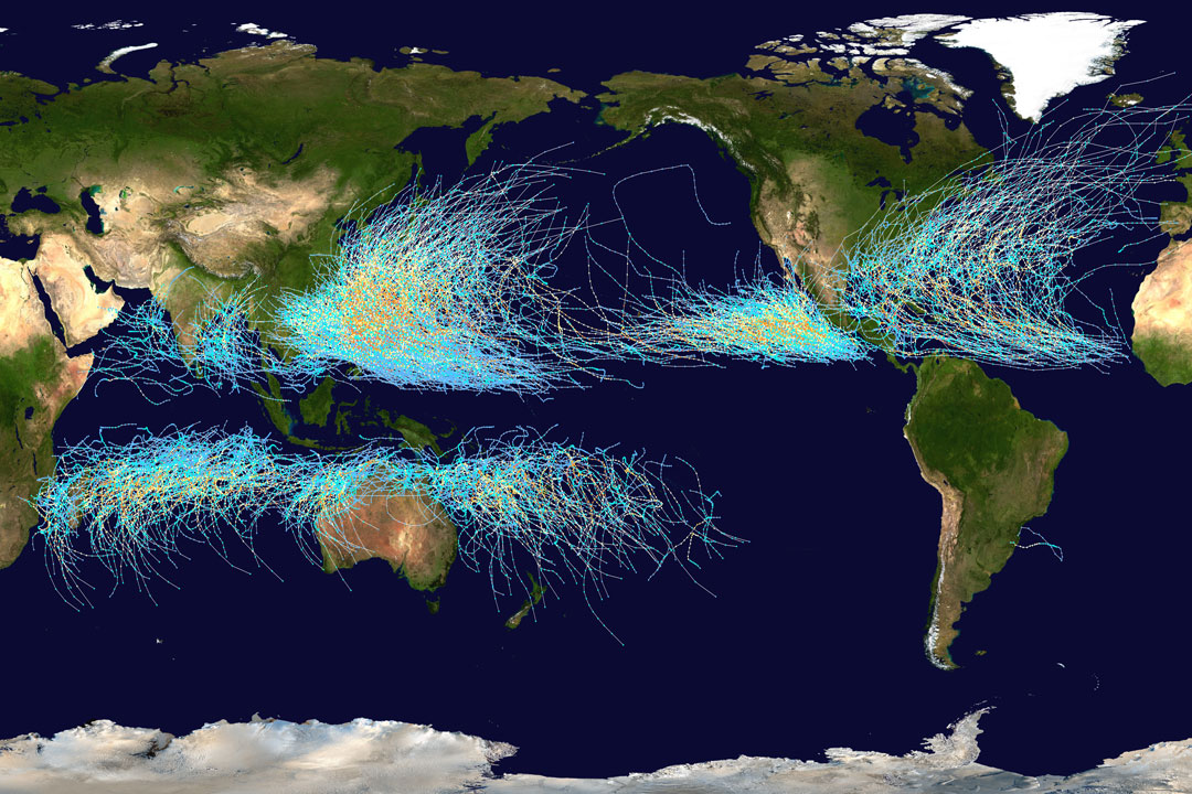
飓风到底去了哪里?通常在大西洋被称为飓风,在太平洋被称为台风,这张特色地图显示了从1985年到2005年所有主要风暴的路径。地图上的图形显示,气旋通常发生在水面上,这是有道理的,因为蒸发的温水给它们提供了能量。这张地图还显示,气旋从来没有穿过——也很少接近——地球赤道,因为科里奥利效应在那里趋于零,而气旋需要科里奥利力来循环。科里奥利力还使气旋路径呈弧形远离赤道。尽管长期趋势仍然是一个研究课题,但有证据表明,在过去30年里,北大西洋的飓风平均变得更加强大,而且预计它们的力量还会继续增强。在Instagram上关注APOD:英语,波斯语,印度尼西亚语,波斯语或葡萄牙语
查看原文解释
Where on Earth do cyclones go? Usually known as hurricanes when in the Atlantic Ocean and typhoons when in the Pacific, the featured map shows the path of all major storms from 1985 through 2005. The map shows graphically that cyclones usually occur over water, which makes sense since evaporating warm water gives them energy. The map also shows that cyclones never cross -- and rarely approach -- the Earth's equator, since the Coriolis effect goes to zero there, and cyclones need the Coriolis force to circulate. The Coriolis force also causes cyclone paths to arc away from the equator. Although long-term trends remain a topic of research, evidence indicates that hurricanes have become, on the average, more powerful in the North Atlantic over the past 30 years, and their power is projected to keep increasing. Follow APOD on Instagram in: English, Farsi, Indonesian, Persian, or Portuguese